   <!--more--> More details can be found on the official website of the city of Split. |
NEW LINKS
Apartments Jaklin
Our guests are primarily provide peace and comfort in the apartments with three stars. All the apartments are comfortable and well equipped, with air conditioning and satellite television. Each apartment has a covered terrace overlooking the sea, the Barbat channel islands (Rab, Cres, Losinj) and Velebit.
http://www.apartmani-jaklin-rab.com
Apartments Hrabar
A family house, located just 500m from the heart of the UNESCO protected old town of Trogir.
http:// |
Tuesday, November 26, 2013
Split
Tourist city located in central Dalmatia in Split (Marjan) peninsula, which today has about 178,192 inhabitants. Superb transport links (airport, modern highways, fast ferry, train and bus stations) this made the city easily accessible for tourists from all over the world and its surroundings. Another is a city and largest port in Croatia and when it comes to the number of passengers - the third Mediterranean ports. Split is the patron Saint Duje.
The biggest attraction and symbol of the city is certainly the Palace of Diocletian in the 4th century, which is due to its unique history 1979th was inscribed on the UNESCO list of World Heritage Sites in Europe. Split today provides a wide range of private accommodation, apartments, hotels, campsites and rooms for rent. Prices are colorful and svačji pocket.
From the sights of this beautiful city and attractions that everyone should visit if he comes to this city we recommend:
First St. Vitus Cathedral. Duje
Second Mestrovic Gallery
3rd City Museums
4th Prokurative
5th Gripe Fortress
6th Peristyle
7th Temple of Jupiter
8th Croatian National Theatre in Split
9th Split Summer
10th Split Festival
Famous people from Split: Diocletian, the Roman emperor, Oliver Dragojevic, a famous singer of popular music, Goran Ivanisevic - Wimbledon winner, the best Croatian tennis player, Branka Vlasic, Croatia's best athlete, Slaven Bilic, formerly known footballer, now respectable football coach, Ivo Tijardović, a famous composer and many others.
Split peninsula surrounded by some of the most beautiful islands in the Mediterranean and Croatian: Brac, Hvar, Solta and Ciovo. Fast ferry line will quickly let you switch to one of them.
Tourists looking for a rich night life and partying until the early hours of the morning, you'll find absolutely everything. Trendy discos, bars and clubs that host the world famous DJ dance will be the most demanding. When the turn comes to cuisine this city has restaurants, taverns, inns and hotels offer every guest the best meals.
Guests prefer an active holiday, you can enjoy all the water sports, hiking, cycling, soccer because we all know that's just split a city of sport.
Split is also ideal for family vacations. Provides a wonderful day trips to some of the island or visit one of the national parks. Beautiful seaside promenade, waterfront, parks, quiet coves and clear waters will provide great holiday everyone.
In this article we will present you with a few photos of Split.
Monday, November 25, 2013
Sun city Hvar
Hvar is a Croatian island in the Adriatic Sea, just off the Dalmatian
coast. Hvar is also the name of the largest city on the island.
Home to 4,200 permanent residents, the population of Hvar increases significantly during the summer as it is a very popular tourist destination full of hotels, restaurants, bars and clubs – and of course the Mediterranean climate and endless beaches.
We got the morning ferry from Split, and 75 minutes later, were docked in the port at Hvar.


Hvar was an independent commune of the Venetian Empire during the 13th to 18th centuries, and was an important trading port and naval base. Prior to this, Hvar was part of the Greek Empire and the Roman Empire. The city walls, as well as many of the buildings of this era are still standing today.
Home to 4,200 permanent residents, the population of Hvar increases significantly during the summer as it is a very popular tourist destination full of hotels, restaurants, bars and clubs – and of course the Mediterranean climate and endless beaches.
We got the morning ferry from Split, and 75 minutes later, were docked in the port at Hvar.
Hvar was an independent commune of the Venetian Empire during the 13th to 18th centuries, and was an important trading port and naval base. Prior to this, Hvar was part of the Greek Empire and the Roman Empire. The city walls, as well as many of the buildings of this era are still standing today.
Blue cave
First,
you must get yourself to the Croatian island of Vis, by ferry from the
city of Split. Once there, travel by bus or motorbike to the other side
of the island, to the tiny fishing town of Komiza. There, hire a boat or
tour to take you to the island of Bisevo, about an hour boat ride from
Komiza. Then you will approach the cave via a small rubber raft, which
is just small enough to enter the tiny cave entrance.

The Blue Cave (Modra špilja) is located at the Balun Cove on the eastern side of the island. Though Croatian fisherman have known of the blue cave since ancient times, it wasn't until 1884 that a (relatively) easy entrance was blasted out with dynamite. Before this small hole in the side of the rock was opened, the only entrance into the cave was to dive underneath the rock wall in just the right spot.

The cave is at its most beautiful between 11 am and 12 pm on a sunny day. The bright blue glowing effect is created when the sun's rays enter through the water and reflect off the limestone floor of the cave. The bright sun lights up the water, and the glowing ocean illuminates the cave walls a brilliant blue, creating an ethereal glowing blue grotto.
Though not an easy trek, it is a rewarding one – the blue cave is a truly enchanting natural wonder.
Zadar the city with most beautiful sunset
Zadar, the city with most beautiful sunset, is one of
those cities that knows how to combine a milennial history with modern
urban development. The town is fast-growing; the UK media once called it
the entertainment hub of the Adriatic, but the town has managed to
preserve the look that it obtained during the Roman period.
A unique tourist attraction is The Sea Organ, a set of large marble waterfront steps and an experimental musical instrument where sea waves create harmonic sounds. Zadar is proud of its historical patina and the lively Mediterranean temperament. The city is one of the most popular tourist destinations in Croatia, London Times named it “the center of entertainment on Adriatic”, and Guardian “Croatia’s new capital of cool”.
Accommodation: Hotels, motels, apartments, private rooms, rural farms in the hinterland.
Dubrovnik, beautiful city on the Mediterranean
"Those who are looking for paradise on Earth should come and see Dubrovnik."
George Bernard Shaw
Dubrovnik, a city of rich history and the center of Dubrovnik-Neretva County, is positioned in the southernmost part of Croatia, on the Adriatic Sea. Dubrovnik is only 25 km away from the international airport of Dubrovnik which is connected to the majority of big European cities by regular flights and located only 90 km from the freeway connecting Croatia to the rest of Europe. In addition to very good air and land transportation links, Dubrovnik also boasts excellent maritime transport connections. Dubrovnik Seaport is one of the most visited in the world.
In early 19th century first celebrities already started visiting the city. Apart from royal families’ members, presidents and diplomats, the biggest names in show business, culture, sports and the business world have also visited Dubrovnik. In 1979. Dubrovnik is added to UNESCO’s World Heritage list.
Croatian traditional cuisine
A famous saying – ”love goes through the stomach”
– really pins down the intricate, yet straightforward relationship
between love and food. As with people, the same goes for places – in
most cases a traveler falls in love with a country by falling in love
with its food. Yes of course, you can be spellbound by the scenery,
fascinated with the architecture, charmed by tradition and way of life,
but not until you sit down and treat yourself with a local delicacy, do
you really get to know a foreign country. A local dish is actually a
symbolic shortcut which employs all your senses at once, introducing you
to a foreign culture in the best possible way – through the pleasure of
eating.
And that’s why we’ve decided to make a top ten list of Croatian delicacies you should try not to miss. Keep in mind Croatian cuisine
is as diverse as the country’s past. The turbulent history of different
nations’ influences (ancient Greeks and Romans, Italians, Turks,
French… to name a few) left its mark on both culture and food. Today we
might say that Croatian cuisine is divided into coastal and interior,
the first being more Mediterranean, and the latter more continental. But
the common factors are freshness and diversity of local seasonal
ingredients, and above all the slow food quality of each dish. So we dare you not to fall in love :)
2. Paški sir – is cheese from Pag Island and it’s made entirely from milk produced by sheep grazing freely local sparse grass, various herbs and aromatic plants. The result of all this is its special flavor which has been recognized globally and awarded year after year. During its preservation it’s coated with olive oil and wrapped in cloth. The most popular varieties of Paški sir are the mature ones due to their strong, distinctive taste. Traditionally it’s cut in thick triangle slices and served with pršut, or grated over seafood pasta.
Istra - region of culture
Throughout its extremely rich history, Istria has been the meeting
place of many nations and their cultures. The Liburni, the Histri, the
Greeks, the Celts, the Romans, the Ostrogoths, the Byzantines, the
Langobards, the Croats, the Franks, the Venetians, the Austrians, the
Italians, the Slovenians…with their presence, they left the traces that
today's inhabitants of Istria try to preserve, ennoble, and update.

Rich ancient historic sites (Šandalja, Romuald's cave...) witnessing the colonization of the first inhabitants, Histri's hill-forts from the Bronze Age (Nesactium, Monkodonja...); ancient Roman monuments (the Amphitheatre Arena, the Sergi Arch, the Augustus' Temple, remnants of numerous Roman villas...); the complex of the Euphrasiana Basilica in Poreč from the 6th century listed on the UNESCO's list of protected cultural heritage; other valuable sacral heritage such as the little medieval churches with fresco paintings (St. Barnabus in Vižinada, St. Foška in Batvači, St. Martin in Lovreč, St. Margaret near Vodnjan), and the especially famous gem of the medieval mural painting Dance Macabre in the little church of St. Mary on Škrilinah near Beram, the largest Istrian church St. Blaise in Vodnjan with the collection of sacral art disposing of 730 works and objects from the period between the 5th and the 19th century and preserved mummified bodies of several saints; remnants of Glagolitic influence in the medieval art and literacy; medieval castles and forts in Dvigrad, Svetvinčenat, Pazin, Pula, Momjan, Pietrapelosa near Buzeta; historic town nucleus of the little towns in the Istrian interior and on the coast; numerous Austrian fortifications from the 19th century in the vicinity of Pula, Italian architecture between the two World Wars with the mining settlement Raša - a separate zoning unit; recognizable traditional rural architecture with dry walls and "kažuni"- unique dry-wall stone houses in the nature with circular form, are only a part of the rich cultural heritage and contours of the remnants of the unique history of "Terra Magica" (Magic Land), as Istria is frequently called by many people.

Diversity, size, and richness of findings are a precondition for many times successfully proven work of a whole series of institutions. Archaeology Museum of Istria Pula, History Museum of Istria Pula, Ethnography Museum of Istria Pazin, Native Museums in Umag, Poreč, Rovinj, Labin, Buzet, and Pazin in collaboration with the Conservation Office - Administration for the Protection of Cultural Heritage, with their professional and dedicated work preserved these unique monuments and civilisation richness for future generations.
Rich ancient historic sites (Šandalja, Romuald's cave...) witnessing the colonization of the first inhabitants, Histri's hill-forts from the Bronze Age (Nesactium, Monkodonja...); ancient Roman monuments (the Amphitheatre Arena, the Sergi Arch, the Augustus' Temple, remnants of numerous Roman villas...); the complex of the Euphrasiana Basilica in Poreč from the 6th century listed on the UNESCO's list of protected cultural heritage; other valuable sacral heritage such as the little medieval churches with fresco paintings (St. Barnabus in Vižinada, St. Foška in Batvači, St. Martin in Lovreč, St. Margaret near Vodnjan), and the especially famous gem of the medieval mural painting Dance Macabre in the little church of St. Mary on Škrilinah near Beram, the largest Istrian church St. Blaise in Vodnjan with the collection of sacral art disposing of 730 works and objects from the period between the 5th and the 19th century and preserved mummified bodies of several saints; remnants of Glagolitic influence in the medieval art and literacy; medieval castles and forts in Dvigrad, Svetvinčenat, Pazin, Pula, Momjan, Pietrapelosa near Buzeta; historic town nucleus of the little towns in the Istrian interior and on the coast; numerous Austrian fortifications from the 19th century in the vicinity of Pula, Italian architecture between the two World Wars with the mining settlement Raša - a separate zoning unit; recognizable traditional rural architecture with dry walls and "kažuni"- unique dry-wall stone houses in the nature with circular form, are only a part of the rich cultural heritage and contours of the remnants of the unique history of "Terra Magica" (Magic Land), as Istria is frequently called by many people.
Diversity, size, and richness of findings are a precondition for many times successfully proven work of a whole series of institutions. Archaeology Museum of Istria Pula, History Museum of Istria Pula, Ethnography Museum of Istria Pazin, Native Museums in Umag, Poreč, Rovinj, Labin, Buzet, and Pazin in collaboration with the Conservation Office - Administration for the Protection of Cultural Heritage, with their professional and dedicated work preserved these unique monuments and civilisation richness for future generations.
Zagreb Capitol of Croatia
ZAGREB, the capital of Croatia, -situated on the
slopes of Medvednica Mountain (Zagrebacka Gora) and along the banks
of the Sava river; elevation 120 m; population 706,770. The favourable
geographic position in the south-western part of the Pannonian Basin
which extends to the Alpine, Dinaric, Adriatic and Pannonic regions,
provides the best valuation of traffic connection between Central
Europe and the Adriatic Sea. The city core comprises the mediaeval
parts of the town called Gradec (Gric) and Kaptol. The construction
of the railway embankment (1860) enabled the old suburbs, which
did not represent an urban whole up to then, to merge gradually
into Donji Grad, characterized by a regular block pattern.

Between
the two World Wars working-class quarters emerged between the railway
and the Sava, and residential quarters on the hills of the southern
slopes of Medvednica. The blocks between the railway and the Sava
were built after the Second World War, and from the mid-1950s new
residential areas south of the Sava river, the so-called Novi Zagreb
(New Zagreb). The cargo railway hub and the international airport
Pleso were built south of the Sava. The biggest industrial zone
(Zitnjak) in the south-east represents an extension of the industrial
zones on the western and eastern outskirts of the city, between
the Sava and the Prigorje region. Urbanized lines of settlements
connect Zagreb with the centres in its surroundings: Sesvete, Zapresic,
Samobor, Dugo Selo and Velika Gorica. The traffic position, concentration
of industry (metal-processing, electrical appliances, textiles,
chemicals, pharmaceuticals, printing and leather industries, wood
processing, paper etc.), scientific and research institutions and
industrial tradition underlie its leading economic position. Zagreb
seats central state administrative bodies (legislative, judiciary,
executive, monetary, defence, health care, cultural, educational,
traffic, etc.). There are three main traffic communications: the
western, towards Ljubljana, i.e. West Europe; the eastern, towards
South-eastern Europe and the Near East; the south-western, towards
Rijeka, Croatia's biggest port. The railway running along the Sutla
river and the Zagorje main road (Zagreb - Maribor - Vienna), as
well as traffic connections with the Pannonian region and Hungary
(the Zagorje railroad, the roads and railway to Varazdin and Koprivnica)
are linked with the trunk routes. The railway connection with Bosnia
and Herzegovina, along the Una valley to Split, is currently out
of use due to thewar damage.

Zagreb is a big Croatian tourist centre, not only
in terms of transit from West and Central Europe to the Adriatic
Sea but also as a tourist destination. The city with a tradition
of almost one thousand years celebrated in 1994 its 900th birthday.
Zagreb is not only rich in cultural and historical monuments, museums
and galleries, it also has a variety of modern shops, and offers
good quality of diversified restaurants as well as sports and recreation
facilities. It is a big centre of congress tourism, economic and
business events and trade fairs not only in Croatia but also in
this part of Europe. Being an important junction point, it has road,
air, railway and bus connections with European metropolises and
all bigger cities and tourist resorts in Croatia.
Zagreb has rich civil and cul-tural heritage, dating
from the -----pre-historic period (Veternica Cave, Palaeolithic)
and archaeological finds of the Roman culture (scitarjevo) up to
the present. The historical part of the town, the Upper Town and
Kaptol are a unique urban core even in European terms, and thus
represent the target of sightseeing tours. The old town, its streets
and squares can be reached on foot, starting from Ban Josip Jelacic
Square, the central part and the heart of Zagreb, or by a funicular
in the nearby Tomiceva Street. The old core of the town includes
many famous buildings, churches, mu-seums and institutions as well
as pleasant restaurants and coffee bars.
NATIONAL PARK Sjeverni (North) Velebit
National Park Sjeverni Velebit
includes a diversity of karstic phenomena, flora and fauna, which is
just a part of this natural world. The Park covers the surface of 109
km2, and inside there is the Hajdučki & Rožanski Ledges Strict
Reserve, known for its geomorphological phenomena - the pits. There
are more than 150 pits discovered, out of which the most famous is
Luke's pit, discovered in 1992.
Velebit is an untamed mountainous ridge which looms as large in the Croatian mentality as it does on the ground. Lying adjacent to the Adriatic and occupying over 2,000 sq km in a belt 145km long and up to 30km wide, this limestone mass is a designated UNESCO biosphere reserve. Velebit is perfect for those wanting to explore a fascinating area in solitude. It is possible to hike the whole length of the ridge, following Premuzic’s path and staying in mountain huts, whilst the more compact Paklenica National Park also offers excellent walking opportunities.


Velebit is an untamed mountainous ridge which looms as large in the Croatian mentality as it does on the ground. Lying adjacent to the Adriatic and occupying over 2,000 sq km in a belt 145km long and up to 30km wide, this limestone mass is a designated UNESCO biosphere reserve. Velebit is perfect for those wanting to explore a fascinating area in solitude. It is possible to hike the whole length of the ridge, following Premuzic’s path and staying in mountain huts, whilst the more compact Paklenica National Park also offers excellent walking opportunities.

On the ridge
Despite its proximity to the coast and the pleasant climate of nearby island archipelagos, Velebit’s size ensures that only on the coastal slopes is it typically Mediterranean. On the top of the ridge the climate is consistently continental, with intense summers exacerbated by the scarcity of surface water and then followed by cold, harsh winters. The peaks of Velebit endure temperatures below 0°C on 160 days in a year. July to September are thus the best months to visit.
Despite its proximity to the coast and the pleasant climate of nearby island archipelagos, Velebit’s size ensures that only on the coastal slopes is it typically Mediterranean. On the top of the ridge the climate is consistently continental, with intense summers exacerbated by the scarcity of surface water and then followed by cold, harsh winters. The peaks of Velebit endure temperatures below 0°C on 160 days in a year. July to September are thus the best months to visit.
Velebit’s landscape
Velebit combines sheer size with the jagged intricacies of karst landforms. From afar it has an impressive bulk, with the ridge being untouched by any major transverse passes. On both sides steep slopes sweep downwards, to sea level at the coast and inland to the Lika plateau. Thus, Velebit stands isolated and aloof as a long barrier separating the sea from the interior. The ridge’s limestone has been weathered over thousands of years to create a landscape of deep gorges, sheer cliffs, dark sinkholes, caves and subterranean drainage systems.
Velebit combines sheer size with the jagged intricacies of karst landforms. From afar it has an impressive bulk, with the ridge being untouched by any major transverse passes. On both sides steep slopes sweep downwards, to sea level at the coast and inland to the Lika plateau. Thus, Velebit stands isolated and aloof as a long barrier separating the sea from the interior. The ridge’s limestone has been weathered over thousands of years to create a landscape of deep gorges, sheer cliffs, dark sinkholes, caves and subterranean drainage systems.
As with the climate, the flora of Velebit varies with
altitude and location. The coastal slopes are rocky, with a thin
covering of maquis and scrub. Inland there is considerably more variety,
with broad, leafy woods developing into denser, wilder beech, juniper
and pine forests towards the peaks. Just below the ridge, the flora
becomes sub-alpine with meadows filled with wildflowers. Bears are the
most famous residents of the reserve, but wolves, martens, wildcats,
deer, snakes, golden eagles, griffon vultures and long-eared owls can
also be found.

Risnjak national park
RISNJAK NATIONAL PARK
 National
Park Risnjak is based in Crni Lug near Delnice has 6,400 hectares of
forest areas. With over thirty specific plant communities, a
4.2-kilometers long trail, a mountain lodge, a restaurant and
accommodation capacities, it represents a special attraction and value
of Kvarner and Gorski Kotar - a wide, heavily forested, karst plateau rising to jagged peaks. Easily accessible, owing to the proximity of the main Zagreb–Rijeka road, the area is a popular destination with Croats for walking, climbing and mountaineering. Risnjak National Park
is at the northern end of the plateau and covers over 30 sq km rising
from the tableland at 620m to the main peak, Risnjak, at 1,528m.
National
Park Risnjak is based in Crni Lug near Delnice has 6,400 hectares of
forest areas. With over thirty specific plant communities, a
4.2-kilometers long trail, a mountain lodge, a restaurant and
accommodation capacities, it represents a special attraction and value
of Kvarner and Gorski Kotar - a wide, heavily forested, karst plateau rising to jagged peaks. Easily accessible, owing to the proximity of the main Zagreb–Rijeka road, the area is a popular destination with Croats for walking, climbing and mountaineering. Risnjak National Park
is at the northern end of the plateau and covers over 30 sq km rising
from the tableland at 620m to the main peak, Risnjak, at 1,528m.
The park’s varied climatic influences – the sea from
the south-west, the Dinaric mountains from the south-east, the continent
from the north-east and the Alps from the north-west – have enabled
over 4,000 plant species to prosper. Accompanying these are over a
hundred brown bears, lynx (ris in Croatian and after which the park is
named), wolves, wild cats, wild boar, deer and chamois, as well as 500
species of butterfly.
There are also notable sights outside of the park
itself. Lokvarska is one of several caves open to visitors in the
summer. Over 1,000m long and dropping 140m in depth, the cave features
an impressive array of stalactites, stalagmites and calcifiedway through
it to the 90m Zeleni vir waterfall at the far end. The Cicarija
mountains are just to the west of Gorski Kotar.
A 40km long barrier that blocks Istria off from the rest of Croatia,
the chain peaks at Platnik (1,273m). Being nearer to the sea the climate
is considerably milder than at Risnjak, although there is often still
snow on the summits in May.
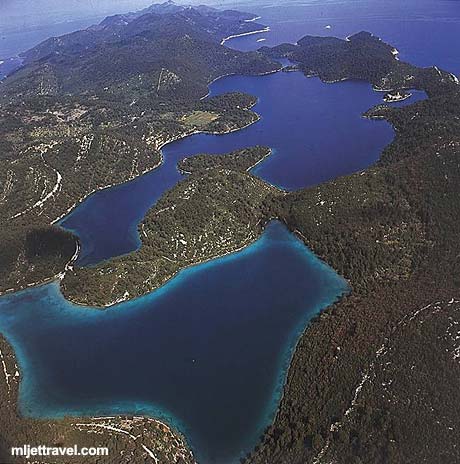
Mljet National Park
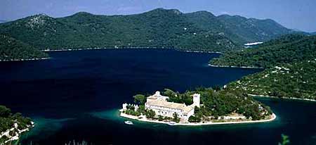
Visiting Mljet National Park
Mljet National Park covers the entire north-west part of Mljet Island see the map bellow).Park’s Main Attractions
Mljet National Park is large area that borders two salt water lakes - Veliko and Malo Jezero (Large and Small Lake). The Lakes stretch for about 4 kilometres. Right in the middle of the Large Lake there is a small island / islet Melita (Sveta Marija) with large building of former Benedictine monastery, erected there in 12th century (see photo above). The monastery’s building is now café/restaurant. The small island is connected by boats that sail there from both sides of the Lake.Map of Nationl Park

Exploring Mljet National Park
As both lakes are encircled by well marked paths, you can cycle or stroll along the pleasant, shaded paths. You can rent a bicycle in Pomena, Polače and at Mali Most to cycle around.Kayaking is also allowed, so if wish, you can rent a kayak at Mali Most (the point where two lakes are joined by narrow channel) to paddle around the Lakes.
Swimming and sunbathing in Park is a good fun - as water here is much warmer than on seashores of the island (which is great if you want to swim in colder months)
To enjoy stunning scenery from hills above the Mljet coastline and Park you can take a hike up the hills (200 m) to get the views.
The Entrance to National Park
The access to the park is at the north or western coast through villages Pomena and Polače. Although there is no official entrance to the National Park as such, visitors are expected to pay for the entrance (buy your ticket at kiosk in Polače or Pomena. Info brochures and leaflets as well as maps of the Park are available in both kiosks.From Polače it takes about 40 minutes to walk along the path through a wood and across the valley to Veliko and Malo Jezero.
From Pomena it takes about 10 minutes to walk to Malo Jezero and another 10 minutes to Small Bridge (Mali Most) from where regular scheduled boats are sailing to Sv, Marija (Melita) islet. Both paths are clearly signed and lead through a nice pine and bay woods.
(Note: No motor vehicles are allowed in the park - you can rent a car and drive along the island, but not in the National Park itself.)
Krka National Park
Krka National Park lies about 10km inland
from Sibenik in this part of Dalmatia. Named after the Krka River, the
Park covers an area of just over 142 square km and includes two thirds
of the river itself. The top attraction of the Park are its magnificent
waterfalls, including the famous Skradinski Buk falls which are one of
Croatia's most famous sights.

Skradinski Buk in Krka National Park
Getting to Krka National Park
Due to its proximity to the coastline, the majority of Krka National Park's visitors are those that find themselves travelling either up or down the Croatian coast. If you're planning on making the Park your first port of call in Croatia, or want to get there easily, the nearest airport to the park is Split Airport. From here, transfer to Split Bus Station and then take one of the many daily buses to Sibenik (journey time about 1 hour 40 minutes).
Due to its proximity to the coastline, the majority of Krka National Park's visitors are those that find themselves travelling either up or down the Croatian coast. If you're planning on making the Park your first port of call in Croatia, or want to get there easily, the nearest airport to the park is Split Airport. From here, transfer to Split Bus Station and then take one of the many daily buses to Sibenik (journey time about 1 hour 40 minutes).
From Sibenik, you can then take a bus to Skradin. At Skradin, you can embark on one of the ferry excursions of the Park.
If you're travelling from
elsewhere in Croatia, likewise make your way to Sibenik first and then
travel on to Skradin and Krka National Park.
Features of Krka National Park
There's a wide variety of both flora and fauna in the Park. Over 800 species of plantlife have been identified as being present in the National Park. Much of the animal life lives, unsurprisingly, in and around the waters of the Krka River which is home to different amphibian and reptile creatures. You will also be able to see many different bird species (there are over 200), and possibly some of the 18 different species of bat who call the Park their home!
There's a wide variety of both flora and fauna in the Park. Over 800 species of plantlife have been identified as being present in the National Park. Much of the animal life lives, unsurprisingly, in and around the waters of the Krka River which is home to different amphibian and reptile creatures. You will also be able to see many different bird species (there are over 200), and possibly some of the 18 different species of bat who call the Park their home!
What to do and see in Krka National Park
As mentioned, the Skradinski Buk waterfalls are a collection of 17 waterfalls that range in height by over 45 metres.
As mentioned, the Skradinski Buk waterfalls are a collection of 17 waterfalls that range in height by over 45 metres.

The island of Visovac
The tiny island of Visovac
in the Krka river was settled by Franciscan monks in 1445, who
originally built a monastery in that year (later demolished, then
rebuilt in the 18th century) and a church in 1576. The monastery
contains a number of well-preserved artifacts and a library.
Roski Slap (slap
being Croatian for waterfall) is another famous sight within Krka
National Park. A series of 12 waterfalls in a space of 450 metres, the
largest is just over 22 metres in height and 60 metres in width.
Undoubtedly the best way of
seeing the sights of the Park is with a boat excursion - a number of
these leave from Skradin. Not only will you be able to see the beauty of
the Park up close (and in a relaxed manner!) but these excursions
include a chance to stop off and wander on footpaths along the water, as
well as presentations and talks and other items of interest.

The River Krka in the National Park
If you're staying in Sibenik,
you will also be able to join a organised excursion to Krka National
Park by visiting one of the local tourist agencies.
Best of all (some might say) - unlike the Plitvice Lakes National Park (although this is done to preserve the waters there), it is possible to swim in places in the Krka National Park.
Accommodation near to Krka National Park
If you want to stay very near to the Park, then the town of Skradin is the top (and only!) choice. Hotel Skradinski Buk is located there, and you'll also be able to find a few private accommodation options. Contact the Skradin Tourist Board for more information.
If you want to stay very near to the Park, then the town of Skradin is the top (and only!) choice. Hotel Skradinski Buk is located there, and you'll also be able to find a few private accommodation options. Contact the Skradin Tourist Board for more information.
Kornati National Park
ORNATI ISLANDS is a group of about 130 islands,
islets and reefs sprinkled in the deep blue sea of the Adriatic covering
an area of about 64 sq km. The Kornati archipelago is in Dalmatia, a coastal region of Croatia just across the cities of Zadar and Sibenik.

The largest island is Kornat from which the archipelago takes its name. Other larger islands are, Piskara, Kurba Vela, Zut, Sit , Vrgada and Levrnaka. Apart from a tiny area of cultivated land with fig trees, olives and vineyards, Kornati islands are rocky, covered with thin grass, rare trees and Mediterranean scrubs.

Over the time erosion has been caused by the sea, over grazing by sheep and fire.This erosion has deprived the islands of their primeval luxurious vegetation, and the people have moved to more hospitable islands. Some of the bigger islands were inhabited during the Neolithic age by Illyrians. A number of wealthy families from Zadar and later Venice have claimed possession of the larger islands.
The Kornati have no permanent inhabitants, although the present owners from nearby larger Dalmatian islands periodically visit Kornati to tend their vineyards and olive groves, bringing their sheep to graze. The sea around the islands is rich with fish and a variety of marine life.... The islands have no spring water, only rainwater collected in water holes.
 The unique feature of the islands lies in their rugged
shores with many caves and coves. The landscape of chalk limestone is
covered with bushes of rosemary, juniper, lavender, thyme, myrtle and
sage. Pathways leading to steep and huge cliffs facing the open sea and
others gently decline towards the sea, ending in a small bay with a
jetty and one or two fishermen's cottages surrounded by pine, olives and
fig trees....
The unique feature of the islands lies in their rugged
shores with many caves and coves. The landscape of chalk limestone is
covered with bushes of rosemary, juniper, lavender, thyme, myrtle and
sage. Pathways leading to steep and huge cliffs facing the open sea and
others gently decline towards the sea, ending in a small bay with a
jetty and one or two fishermen's cottages surrounded by pine, olives and
fig trees....
The largest island is Kornat from which the archipelago takes its name. Other larger islands are, Piskara, Kurba Vela, Zut, Sit , Vrgada and Levrnaka. Apart from a tiny area of cultivated land with fig trees, olives and vineyards, Kornati islands are rocky, covered with thin grass, rare trees and Mediterranean scrubs.
Over the time erosion has been caused by the sea, over grazing by sheep and fire.This erosion has deprived the islands of their primeval luxurious vegetation, and the people have moved to more hospitable islands. Some of the bigger islands were inhabited during the Neolithic age by Illyrians. A number of wealthy families from Zadar and later Venice have claimed possession of the larger islands.
The Kornati have no permanent inhabitants, although the present owners from nearby larger Dalmatian islands periodically visit Kornati to tend their vineyards and olive groves, bringing their sheep to graze. The sea around the islands is rich with fish and a variety of marine life.... The islands have no spring water, only rainwater collected in water holes.

Brijuni National Park
Every day, three times on the day from FAŽANA: at 09,15, 11,30, 15,15 h.
Brijuni National Park is an oasis of the magnificent harmony between man, animal and plant life. There are almost 700 plant species and about 250 bird species on the islands, whereas the mild Mediterranean climate makes it a pleasant health resort.
 After leaving Fažana, the line of
green islands viewed from the boat, transforms into Veliki Brijun, the
largest of the 14 islands. The traces of dinosaurs, remains of Antiquity
and later periods, achievements of modern times are all present in this
area, whose development as an exclusive resort starts in 1893 thanks to
the “old Austrian” Paul Kupelwieser, owner of the Brijuni Islands. This
fashionable seaside resort and one of the leading health resorts
started developing and gaining popularity all over Europe and worldwide.
After leaving Fažana, the line of
green islands viewed from the boat, transforms into Veliki Brijun, the
largest of the 14 islands. The traces of dinosaurs, remains of Antiquity
and later periods, achievements of modern times are all present in this
area, whose development as an exclusive resort starts in 1893 thanks to
the “old Austrian” Paul Kupelwieser, owner of the Brijuni Islands. This
fashionable seaside resort and one of the leading health resorts
started developing and gaining popularity all over Europe and worldwide.

From then on Brijuni were mostly known as a summer residence of Marshal Josip Broz Tito, the president of former Yugoslavia, who arrived on Brijuni for the first time in 1947. The usual, short introduction to Brijuni is a tour by tourist train that takes visitors through all the different natural beauties; through the safari park, by the Byzantine castrum, Roman residential villa in Verige Bay and many other interesting sights. Right by the harbor, there is the church of St. German from the 15th century which houses an exhibit of Istrian frescoes and copies of Glagolitic monuments. Nearby is the natural science exhibit, archaeological museum and exhibition "Tito on Brijuni".
Brijuni National Park is an oasis of the magnificent harmony between man, animal and plant life. There are almost 700 plant species and about 250 bird species on the islands, whereas the mild Mediterranean climate makes it a pleasant health resort.

From then on Brijuni were mostly known as a summer residence of Marshal Josip Broz Tito, the president of former Yugoslavia, who arrived on Brijuni for the first time in 1947. The usual, short introduction to Brijuni is a tour by tourist train that takes visitors through all the different natural beauties; through the safari park, by the Byzantine castrum, Roman residential villa in Verige Bay and many other interesting sights. Right by the harbor, there is the church of St. German from the 15th century which houses an exhibit of Istrian frescoes and copies of Glagolitic monuments. Nearby is the natural science exhibit, archaeological museum and exhibition "Tito on Brijuni".
Kopacki rit nature park

Kopački rit is a floodplain that developed due to the activities of two large rivers, the Danube and the Drava. Significant flood areas exist in the northern, southern and western surrounding parts of the Nature park that stretch from Batina up north, to Bijelo Brdo down south and Donji Miholjac towards west. Geographically speaking, Kopački rit covers the area between the 45° 32' - 45° 47' northern geographical latitude and 18° 45' - 18° 59' eastern geographical longitude. The altitudes of Baranja do not exceed 250 m, and the Nature Park is at the lowest altitude starting from only 78 m above sea level (the bottom of Kopačko Lake) to 86 m above sea level.
Bilje, Kopačevo, Vardarac, Lug, Grabovac, Kneževi Vinogradi, Suza, Zmajevac, Batina and Zlatna Greda settlements are all situated in the western and northern surrounding areas of the Nature Park on the margin of the former floodplain. Bilje has become a transitionally stronger urban settlement while the other settlements have remained rural.
Osijek is situated on the right riverbank of the Drava, southwest of the Nature Park as a macro regional center of eastern Croatia, while Podravlje is its suburban settlement on the left riverbank of the Drava. Nemetin, Sarvaš, Bijelo Brdo and Aljmaš settlements are on the south and southeastern side only 5,0 km air distance from the Nature Park.

Kopački rit has a typical relief structure because of the river's water activity and the floodwaters that flood the area. Rivers create banks and islands called “ade” and armbands called 'dunavac' or 'old Drava' in their live streams. On the other hand, the water in the floodplain deposits sediments in one place but deepens the ground in another, so the whole area obtains a specific undulate appearance. That is how ponds (depressions) and beams (higher grounds) were created and stretch hundreds of meters next to one another. Ponds and beams are narrow and long and have a specific curved appearance from the sky. The altitude difference between ponds and beams is 8 m. max. The ponds meet by the ends through a natural channel or so-called 'fok' and enter “Dunavac” or the Danube. The beams fill and empty the ponds. “Foks” were artificially deepened and the trenched canals took over the “foks” function.
This kind of pond and beam layout gives the area a unique appearance. The entire floodplain obtains a delta kind of look and is extremely exceptional because the Danube creates a so-called “inland delta” in its middle stream with the assistance of the Drava. A phenomenon like this is not notable for other European rivers in this form and therewith gives this area a global significance. If ever, Kopački rit shall be enrolled on the World Natural Heritage List having this phenomenon, because many other larger and more significant rivers in the world do not have it.
Kopački rit was designated on the List of Ramsar areas in 1993. Protected areas on that List are protected under the Convention on Wetlands of International Importance, especially as a waterfowl habitat. The Convention was signed in a city called Ramsar (Iran) in 1971, (so called Ramsar Convention). Croatia is a full member under this Convention from 1991. Almost 1700 areas in the world have been designated on the List of Ramsar areas until today covering more than 150 million hectares. Kopački rit is also on the list of Important Bird Areas (IBAs). This program was developed by Birdlife International (a global association for bird protection; their habitat; and global bio-diversity that focuses people to the sustainable usage of natural resources) so to determine, supervise and protect the global network areas that are important habitats for birds and for the bio-diversity in general. The partners in this association take full responsibility for the enforcement of the program on a national scale. More than 7500 areas in over 170 countries have been designated on the IBAs list from 2004.

Besides that, the Nature Park and Special Zoological Reserve were assigned as an area of international importance being part of the “Natura 2000 Networking Program”, so Kopački rit will be a significant candidate to join this network when Croatia accesses the European Union. An ecological network is a system of the most valuable areas for endangered species, habitats, ecological systems, and landscapes that are sufficiently close to each other and connected with corridors. This kind of system enables an interactive communication and species exchange. Parts of the Danube and Drava floodplains outside the Nature Park are also of international importance.
Plitvice Lakes National Park
Plitvice Lakes National Park is one of the greatest natural wonders
of Europe. Embraced by high wooded mountains, one beneath another lie
sixteen beautiful lakes of crystal blue-green water. Connected to each
other by a series of foaming cascades and thundering waterfalls, the
lakes are fed by many rivers and streams. Over the millennia, waters of
these lakes have dissolved the limestone rock and carved out the valley
in which they now lie.
 Through the process of sedimentation of calcium carbonate and the work
of special kinds of algae and moss, tufa or travertine has been
deposited, and is still deposited to form the natural dams that separate
the lakes.
Through the process of sedimentation of calcium carbonate and the work
of special kinds of algae and moss, tufa or travertine has been
deposited, and is still deposited to form the natural dams that separate
the lakes.
Since the process is going on today, just as it always has, new travertine barriers, curtains, stalactites, channels and cascades are being built and the existing ones are changing. As it is deposited, the tufa coasts the beds and banks of the lakes, giving the water sparkling beauty and petrifying trees and stones which fall into the lakes. The water keeps breaking through the travertine barriers at different places, so that the entire process of formation of lakes and dams is alive and very dynamic.


 This is, in fact, a continuous dynamic process
of tufa formation, a unique, interesting natural phenomenon. Nature's
construction work continues in undisturbed ecological conditions. Beside
the lakes are some interesting caves in which remains of prehistoric
settlements have been found. The National Park covers an area of 29482
hectares, of which 22308 hectares of forest, 217 of lakes and streams,
and 6957 of meadow and farm land. These forests, which in some places
seem almost primeval, contain a wealth and variety of animal and plant
life. There are deer, bears, wolves, wild boar, wild cats, small game
and many kinds of birds. The waters have excellent trout. Hunting,
fishing and swimming are not allowed.
This is, in fact, a continuous dynamic process
of tufa formation, a unique, interesting natural phenomenon. Nature's
construction work continues in undisturbed ecological conditions. Beside
the lakes are some interesting caves in which remains of prehistoric
settlements have been found. The National Park covers an area of 29482
hectares, of which 22308 hectares of forest, 217 of lakes and streams,
and 6957 of meadow and farm land. These forests, which in some places
seem almost primeval, contain a wealth and variety of animal and plant
life. There are deer, bears, wolves, wild boar, wild cats, small game
and many kinds of birds. The waters have excellent trout. Hunting,
fishing and swimming are not allowed.
There are two entrances to the National Park (Upper and Lower Lakes). On the panoramic map these are marked 1 and 2. Big notice boards at each entrance provide visitors with basic information concerning walking trails through the Park and the locations of viewpoints, car parks, hotels, post office, bus stops, first-aid posts, etc. The trails are also marked on the tickets that visitors buy when enter. All other information (accommodation, food, connections with the coast and the other part of Croatia, traffic information, etc) is provided by the Park staff in the information offices.
Since the process is going on today, just as it always has, new travertine barriers, curtains, stalactites, channels and cascades are being built and the existing ones are changing. As it is deposited, the tufa coasts the beds and banks of the lakes, giving the water sparkling beauty and petrifying trees and stones which fall into the lakes. The water keeps breaking through the travertine barriers at different places, so that the entire process of formation of lakes and dams is alive and very dynamic.


There are two entrances to the National Park (Upper and Lower Lakes). On the panoramic map these are marked 1 and 2. Big notice boards at each entrance provide visitors with basic information concerning walking trails through the Park and the locations of viewpoints, car parks, hotels, post office, bus stops, first-aid posts, etc. The trails are also marked on the tickets that visitors buy when enter. All other information (accommodation, food, connections with the coast and the other part of Croatia, traffic information, etc) is provided by the Park staff in the information offices.
Rajska Beach Lopar Croatia
On the northern side of the Island of Rab, in an open bay is located a
small picturesque place Lopar, which has beautiful sandy beaches. The
most famous is Rajska beach which spreads for 1,5 kilometers and has
many tourist facilities and rich gastronomy offer. The beach is sandy
and shallow which is ideal for little kids and non-swimmers. The beach
is kept by lifeguards, so you can carelessly enjoy in all summer
beauties.

The climate conditions are great for water sports, and there are also many sport fields, cycling paths, diving schools, and you can rent a scooter or a pedal boat or refresh yourself in one of many bars and restaurants which can be found on the beach or above the beach in the tourist settlement San Marino.
The beach is awarded with a Blue flag which is a symbol of high quality and a rich tourist offer.
Punta Rata Beach Brela Croatia
The beach Punta Rata is located in Brela, which is one of the most
famous Croatian seaside resorts with a beautiful beaches and long
walking paths by the coast. Almost all beaches on Makarska Riviera are
awarded with a Blue flag as a symbol of purity and quality, and the
beach Punta Rata is chosen in 10 the most beautiful beaches in the
world, and as the most beautiful in Europe.
 The beach is pebbly,
and at the sea entrance sandy which is great for kids. It is surrounded
with pine trees which provide shade. On the beach there is a big rock
which peeks out from the sea, and it is great if you decide to separate
from the crowd.
The beach is pebbly,
and at the sea entrance sandy which is great for kids. It is surrounded
with pine trees which provide shade. On the beach there is a big rock
which peeks out from the sea, and it is great if you decide to separate
from the crowd.
Around the beach you can find many bars and restaurants, where are offered many different meals and drinks. On the beach you can rent different sport props.

Around the beach you can find many bars and restaurants, where are offered many different meals and drinks. On the beach you can rent different sport props.
Vela Plaza Beach Baska Croatia
The Island of Krk is one of the islands in a Kvarner bay which
possesses numerous picturesque places, many natural bays and beautiful
sandy and pebbly beaches. On the southern part of the island is located a
famous tourist resting place Baska, which is famous for one of the most
beautiful beaches in Kvarner bay.

In a protected bay which is shielded by the mountain Velebit, spreads a long pebbly beach Vela plaza which is awarded with a Blue flag. Everyone can find here its place to take a rest or to have fun. Some parts of the beach are sandy which is great for kids. Young people will be attracted by the sounds of a music that comes from attractive bars on the beach. There are offered also many activities on the sea, and you can rent a pedal boat, scooters and other. Here is also an aquagan and one high slide for the braver ones.
Near the beach you can find many snack-bars, shops and restaurants. Vela plaza is an ideal place where you can expect to find a lots of fun and memories.
Bijeca Beach Medulin Croatia
Medulin is a well known tourist place with a special offer for
accommodation and facilities. It has a beautiful coast with many
beautiful beaches and it is surrounded by many islets. The most famous
beach in Medulin is Bijeca, which spreads 1km by the coast. The beach is
sandy with a nice entrance to the sea, which is great for kids and
older people, and younger will be attracted by volleyball in the shoal.
You can rent here deckchairs and parasols, and for kids there is an
aquagan. Above the beach you can find a place for you in the shade of
trees, so on the beach Bijeca you can spent entire day.
In the place are located many restaurants, shops and bars. Medulin is an ideal place for a vacation, where you can find peace, but also a good time.

In the place are located many restaurants, shops and bars. Medulin is an ideal place for a vacation, where you can find peace, but also a good time.

Subscribe to:
Comments (Atom)